Kaikoma (Yamanashi)
- Tee

- Jun 18, 2023
- 3 min read
Updated: Apr 20, 2025

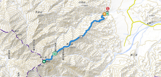
Kaikomagatake 2967m with it's famous "swords" is a beautiful and challenging hike in the Southern Alps. This post describes the trail from Ojiragawa Canyon with the Kuroto ridge. The route is very steep and one of Japan's steepest ridgelines (top 3). The hut is open year-round and camping is possible as well.
⏲︎	Time: 14h30min
✎	Kanji: 甲斐駒ヶ岳
⚲ 	Location: Yamanashi
↔	Distance: 17.8km
✮	Difficulty: Difficult
ᨒ	Elevation Gain: 2509m
☀	Multiday: 2D/1N
☉	Hiking Season: Mid July to
	mid October

Access
Car
Park at the trailhead at Ojiragawa Gorge. If you’re hiking on the weekend/holidays come early as the parking lot is small and the gorge is also popular for daytrips. In June we arrived at 6am and the parking lot was full. Our tent neighbor had to park further away and walk for a while.
Public transportation
Public transportation access is a little difficult for the Kuroto ridge trailhead. There is no direct bus and you have to take a mountain taxi from the station. It only runs once a day and only from mid June to mid November. It also needs to be reserved the day before on their website. (There at 9:00 and back at 16:00; cost 1500¥ on weekdays/1800¥ holidays and weekend). Or take a normal taxi from Kobuchizawa Station.
Last option is to walk from the closest bus stop (michi no eki). We picked up our other tent neighbor and she was very happy (45min walk). This is the longest but cheapest option.
Trail description
Day 1: 10km, 7h and 2300m elevation gain (Yamap time estimate 10h)
Start from the parking lot and walk towards the river and shrine. Walk through the shrine and cross the river with the bridge on the left.
Then follow the sign for Kaikoma. The signage is in Japanese only, so familiarize yourself with the Kanji.
The first 3h through the forest are pretty steep and monotonous. Once you get onto the ridge it gets a bit more interesting and you have to climb some ladders and chain sections. There are not a lot of views until you get to the hut (took us 4:20min).
Once you get to the hut drop off your bags (or set up the tent), then continue to the peak. After the hut the trail is a lot more beautiful with views and also more challenging with more ladders and steep chain sections. It’s nothing crazy but definitely more technical. If you're lucky you'll have views of Mt. Fuji, Yatsugatake, Kitadake and also Houou Sanzan.
From the peak it takes about an hour and a half back down to the campsite.

Day 2: 7.6km, 3h and 1800m down (Yamap time estimate 5h)
The next day it takes around 3-4h back down to the start. The trail to and from the hut doesn't have a lot of rocks in the forest section and the ground is soft. The trail is popular for trail runners and we also ran the last section back to the parking lot.
Extra info:
The trail has technical and exposed sections, make sure you have rescue insurance and your abilities match the skill level needed for this trail.
This hike is very strenuous with lots of elevation gain and steep.
The campsite is small and first come, first serve. It’s usually full on the weekend. Come early and bring extra cash to pay for a possible hut stay.
Accomodation
Shichijo Goya: 10.500¥ to 12.000¥ depending on the day. Reservation required.
Tent 1500¥ per person, first come first serve.


Comments