Iriomote Island Crossing (Okinawa)
- Apr 21, 2023
- 3 min read
Updated: Jan 24

The Iriomote Island Crossing is a challenging yet stunning hike that takes you through dense rainforest and along clear rivers in one of Japan’s most remote islands. Careful planning is important, as access to the trailheads and transportation back is complicated. Despite the logistical challenges, the hike across the island is incredible adventure walking through wild, untouched nature.

⏲︎	Time: 10h
✎	Kanji: 西表島のジャングルを横断
⚲ 	Location: Iriomote Okinawa
↔	Distance: 26.5km
✮	Difficulty: Difficult
ᨒ	Elevation Gain: 807m
☀	Dayhike
☉	Hiking Season: year-round

Access
Start at the boat tour dock (下流船着場) for the urauchi river. Take the first boat, which should be at 9:00 am, but check their website beforehand for departure times. They have toilets, snacks, and showers there. Make sure to come early, because you might have to fill out a form again. Then get a one-way ticket for the boat. It's around 2000¥.
Since public transportation is limited on the island it's recomended to either rent a car and park it at the end of the trailhead (close to Otomi village) or stay somewhere close to it and have your guesthouse drive you to the boat dock. If you take the first bus up to the boat, you will not have enough time for the hike!
Taxis are another option, but the drive is an hour long and costly. It will also need to be reserveved in advance.
We parked our rental car at the end the day before, then took a bus back up north (60min) and stayed close to the boat dock and walked to it in the morning.
The road up to the trailhead was locked and we parked next to the road close to the cemetary. If you get a guide they can drive up a little closer.

Trail description
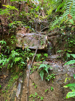
When you get off the boat the first part of the hike is well maintained and a nice little rock path. Until Maryude and Kanpire waterfall it's easy and anybody can walk this secion. It takes about 30min to get there.

After the waterfalls is where the real fun begins. You'll walk up in the riverbed, either directly in the water or in mud. The trail is not well marked and can be slippery. Sometimes is easy to spot and other times it's nearly impossible to tell if you're still on the right track. Keep a constant lookout for the little pink ribbons and if you don't see any for a while turn back. It's very easy to get lost in the jungle, so a gps map from Yamap is essential.
There are a couple of narrow sections and one or two ropes but nothing technical. The main challenge of this hike is not to get lost or take too long.
The last hour or so will be on a gravel road back to the car and downhill.


Land leeches
Iriomote has a lot of land leeches, to avoid them ski socks over pants keep them out. Regular socks will not be thick enough and the leeches can bite through. There are a lot of leeches on this trail, make sure you're prepared.
If they do get through, salt works very well and they come right off.
Extra Info:
The hike is not well-marked, has no cell service, and lots of leeches.
Iriomote is a national park, wild camping is not allowed.
Dont walk this hike alone or during bad weather because of flash floods.
You need to register the hike with the local police and forestry office.
Have a look at the distance and sunlight hours. We got out of the jungle just before sunset. Iriomote has venomous snakes (habu) which usually come out after sunset.